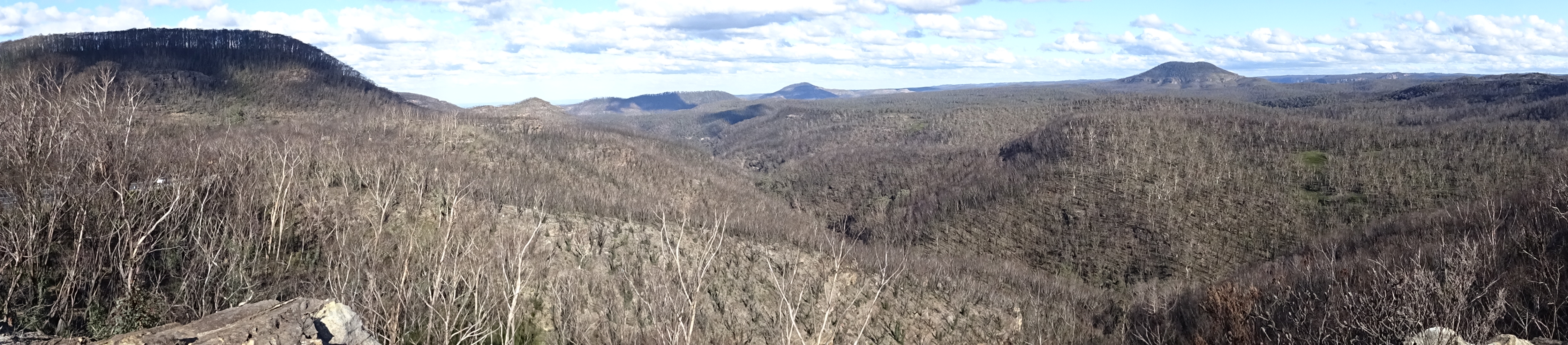
The border between New South Wales and Queensland had been opened early in July and travel was permitted after obtaining an authorisation from the Queensland Government. I decided to take a trip to discover part of the western, desert areas of the state. At one stage of my planned route I would be only 100 miles from the point that three states, Queensland, South Australia and New South Wales, meet.
Friday 17th July
It was foggy in Wagga so I waited until 1030 before departing by which time it had become a lovely sunny day, albeit cold. The temperature peaked at 15C on the approach to Hillston. I stopped in Leeton for lunch and warmed up, particularly my hands, over cake and coffee. It was interesting riding through miles of orange orchards, vineyards and rice fields after Griffith. This area is part of the Murrumbidgee Irrigation System so water for agriculture is plentiful. I booked into a good motel in Hillston and the owner offered the use of his garage to park the bike. In the evening I crossed the road to the ex-Servicemen’s Club for a beer and a meal. My experience to date has been that most of these clubs have Chinese restaurants in them providing the food.
Distance: 293 kilometres.
Saturday 18th July
It was cold and bright on departure and I decided to fill the petrol tank before leaving town. I am pleased that I did as I discovered that the next petrol station on my route in Ivanhoe where I would have needed to refuel had closed down. The road to the Cobb Highway, a distance of some 89kms, was unsealed, pretty rutted and largely single lane.

The terrain was featureless being flat and with only scrub in places.

I reached the Cobb Highway and stopped in Ivanhoe for coffee and a roll. The owner had only the week before installed a wood burning stove which provided a warm environment after the chilly ride. I was expecting the town to be quite vibrant given its crossroads location but it was very run down with the majority of businesses closed down and boarded up. The Cobb Highway surprised me as it was 50/50 sealed/unsealed, unusual for such a busy route. The unsealed sections were very bumpy and it looked as though the graded top surface was delaminating.

I saw a number of wild animals beside the Highway, emu, kangaroo, feral goats and feral horses, known here as ‘brumbies’. I reached Wilcannia and booked into a second rate motel where I planned to spend two nights as I wanted to reconnoitre the area before heading north to Queensland. The motel was behind a petrol station which, according to the signage, had a restaurant attached. This appeared to be more like a transport cafe and it served only takeaway meals which ceased at 1830. I walked to the only pub in town which had no draught beer but only bottles and cans in the fridge.

The licencee was Aboriginal and the bar served as a bottle shop. There was a constant stream of people, chiefly indigenous, buying booze to take away. Apart from people playing the fruit machines in the back the only other person in bar was an old Irishman who had been in Australia since the early sixties and who had, and still did, work on road gangs.
Distance: 329 kilometres.
Sunday 19th July
I wished to see White Cliffs which is famous for its opals and opal mines. It also boasts an underground motel which I had decided not to stay in because of fear of claustrophobia. The 95kms road from Wilcannia, the Opal Way, was sealed and although narrow was a joy to ride. The terrain was quite undulating with scrub and small trees in abundance. The place itself was disappointing with little of interest to see. I was approached by a chap in his early thirties who, it appears, had given up his job as an investigator with the Melbourne coroner (he had a degree in Criminology) several years ago and had gone to San Francisco. Although not a motorcyclist he had bought a bike and spent 18 months travelling to Ushuaia in southern Chile. We had an interesting chat and on spotting my GPS emergency beacon he told me a story of a guy he had met who had been stranded in the snow high in the Andes and who had used an identical beacon and had been rescued. I planned to return to Wilcannia on unsealed roads, the latter part of which would form the beginning of my two days of dirt roads into Queensland the following day and I was interested to see the quality of the surface. It is common to ask locally about local road conditions and I expected to glean information on the quality of the road north but in that I was disappointed. In the event the road back to Wilcannia wasn’t too bad. I stopped to lower the tyre pressures a little which helped.


The temperature in the afternoon had risen to 25C and I removed a layer of clothing which augured well for the ride north. On returning to Wilcannia I rode a short way along a busier alternative unsealed road, Louth/Bourke, but that was very corrugated and uncomfortable which convinced me to go ahead and take the original route.


That evening I discovered the Wilcannia Golf Club. It is very similar to the Returned Servicemen’s Clubs and Ex-Servicemen’s Clubs I have seen here and it also sported a Chinese restaurant which is closed on a Sunday! I couldn’t see any golf course in town and this link https://youtu.be/IwrrenHWeGk explains why. As I returned to the motel I came across an elderly fellow wearing cowboy boots and a Stetson who had been travelling for several years in a horse drawn caravan. He was a real character and I enjoyed an interesting chat with him.

Another healthy (pie and chips) meal from the cafe and I telephoned to book accommodation for the next night in Wanaaring.
Distance: 221 kilometres.
Monday 20th July
A beautiful bright morning 9C. I left Wilcannia at 0900 and tackled the Wanaaring Road. It didn’t appear as bad as the day before. Two motorcyclists passed going on the opposite direction and I saw only 6 other vehicles in 253 kilometres.

The early part of the road was gravel and stones but the latter 50 odd kilometres was sandy and dusty with the bike squirming under me and I almost lost it on one occasion.


I hit a pocket of bulldust and the bike veered across to the side of the road where the verge was deep dust. I resisted the temptation to brake and rolled to a stop with the bars all over the place and I was still in 5th gear when I came to a halt. More about riding technique in sand and bulldust later. I spoke to a Ranger, in one of the aforementioned 6 vehicles, who told me that there had been little rain of late which was needed to pack down the sand and dust. He believed that the road from Wanaaring to Hungerford was less sandy. This information was contradicted in Wanaaring where I was told that the road had just been regraded. (In the event both were wrong!). I observed to the Ranger on the lack of wildlife seen on this stretch. He said that the absence of wildlife was the result of the current drought although there were some kangaroos evident at nighttime.
The cabin in Wanaaring was very small, reminiscent of a cabin in a warship, but was clean and comfortable. The toilet and shower/bathroom were not - very dilapidated and filthy. The site was run from the local, and only store, which also served as the cafe, petrol station (diesel and 1 grade of petrol with pumps padlocked and unlocked and served by store staff), general store and campsite office. The staff were very friendly though and I refuelled (not surprisingly the most expensive fuel to date). I walked to the local river where there was a number of wild geese, strangely silent compared to their European/Scandinavian cousins.

I had fish and chips for supper, strange choice given the location in the middle of the outback but deep freezers are wonderful appliances. The owner lit a wood fire in the middle of the site and I spent some time sitting beside it chatting to a woman and her teenage daughter from Sydney who were camping there for the night on their way home.

Distance: 253 kilometres.
Tuesday 21st July
I left Wanaaring at about 0900 without having had my customary early morning shower. After turning north from the Bourke road in sunshine I saw a number of kangaroos in the road. Most just stared, immobile, before finally deciding to move. It’s no wonder there are so many dead beside the highway. I saw a number of feral goats as well. The road was dusty and sandy but I suffered no dramas.

I reached the Queensland border at Hungerford and was faced with a closed gate.
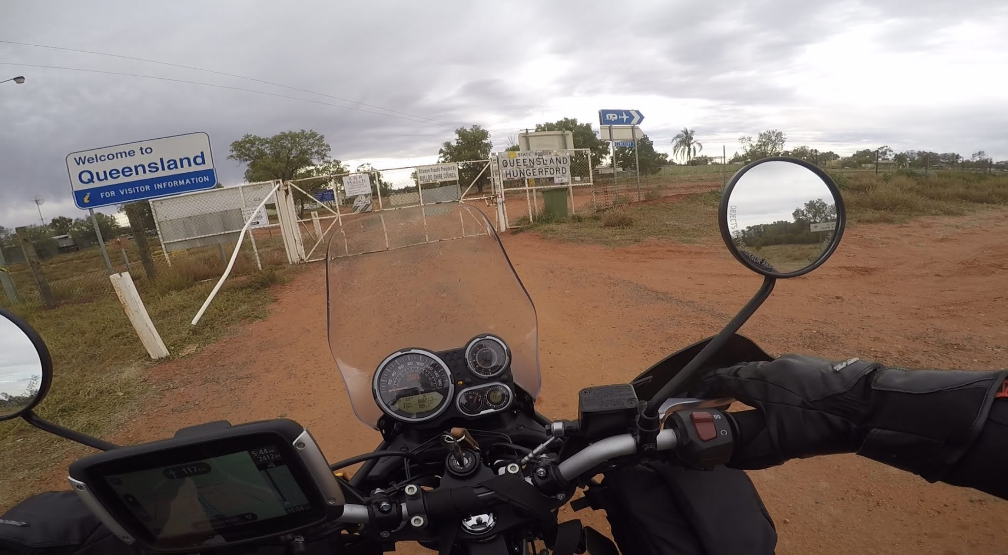
I pondered, thinking that the crossing was closed at this point and was considering alternative routes when it dawned on me that this was the dog fence gate. When the rabbit problem was eradicated in the outback the rabbit proof fence became the dog fence to protect sheep from attack by dingoes. I opened the gate, rode through and closed it after me. I stopped at the Royal Mail Hotel for a coffee (instant) and to enquire about the state of the road north. The bar in the hotel had a number of interesting historical photos, pictures and maps, and a few notices of which this is an example.

As it was evident that there was more sand and bulldust now I was keen to take the shorter route to Eulo to meet the paved road to head west rather than the considerably longer road direct to Thargomindah. I spoke to a bloke who had just driven it in a 4x4 and he said it was OK. When I got to the road there was a barrier across it with a sign saying the road was closed and was suitable only for 4 wheel drive vehicles. I could see that it was quite muddy (as bad as sand and dust on two wheels) so I decided on the Thargomindah route despite its greater length. The road gradually deteriorated as I progressed and clearly it had not been graded for some time.


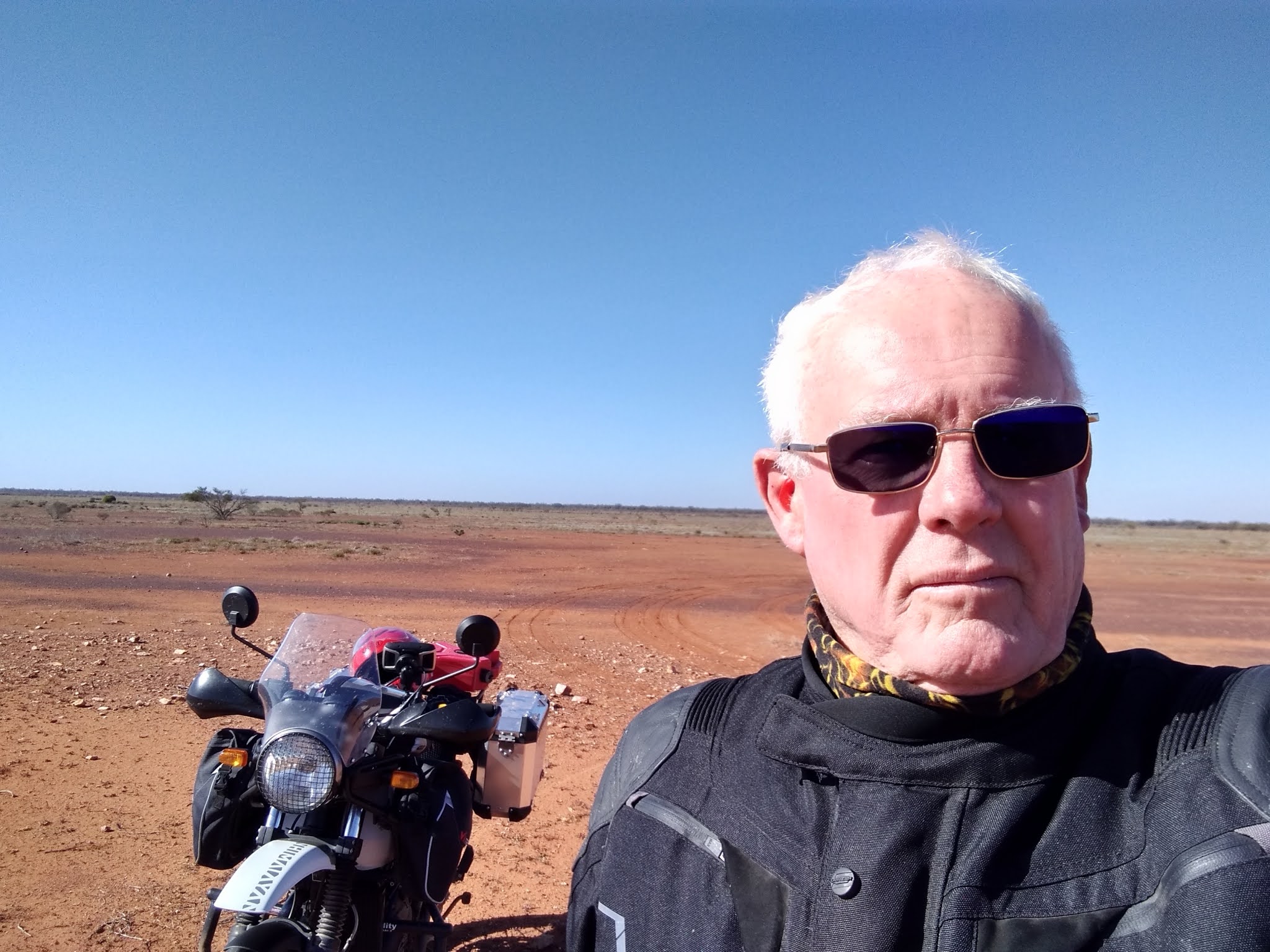
The road was rough and became sandier with pockets of bulldust and after several wobbles I ended up in a deep trough of bulldust on the left side of the road. The bike was fishtailing and suddenly I was sailing through the air and I landed on my back feeling a little winded. The bike was facing the opposite direction with the wheels up on the banked sand. The left hand mirror was broken and the left pannier was compressed. After removing the auxiliary fuel tank from the rack and the inner bag from the pannier I pulled the bike away from the bank and was able to lift it upright. I was so keen to make sure the bike was still rideable that I omitted to photograph it! All seemed in order, albeit slightly bent in places. My right ankle was a little sore as was my back (I will be researching back protectors before my next jaunt off road.). I rode the further 30-40 kilometres to Thargomindah and was delighted to reach bitumen! After checking into the motel I examined the bike, reinflated the rear tyre (my pump gave up when trying to pump up the front but fortunately there was a petrol station with air nearby) and adjusted the chain. I ate in the motel restaurant that night and ordered bangers and mash as a break from chips. The meal arrived with lovely sausages and mash, fresh vegetables and gravy and with chips piled on top!
Distance: 267 kilometres.
Wednesday 22nd July
I left Thargomindah at 0930 with the wonderful prospect following the last few days on unsealed roads of a full day on bitumen on so called ‘development roads’. As I left I heard a strange noise which seemed to be emanating from the rear of the bike. I stopped and had a good look but could see nothing amiss. After a few more kilometres the sound was still there so I stopped and looked again and found a really tight spot on the chain. I adjusted it again, this time properly, and all was well thereafter. The development roads are quite narrow in the main but smooth and traversed interesting, desertish terrain.


I saw areas where termite nests stretched into the distance, albeit not of the scale seen in Western Australia.

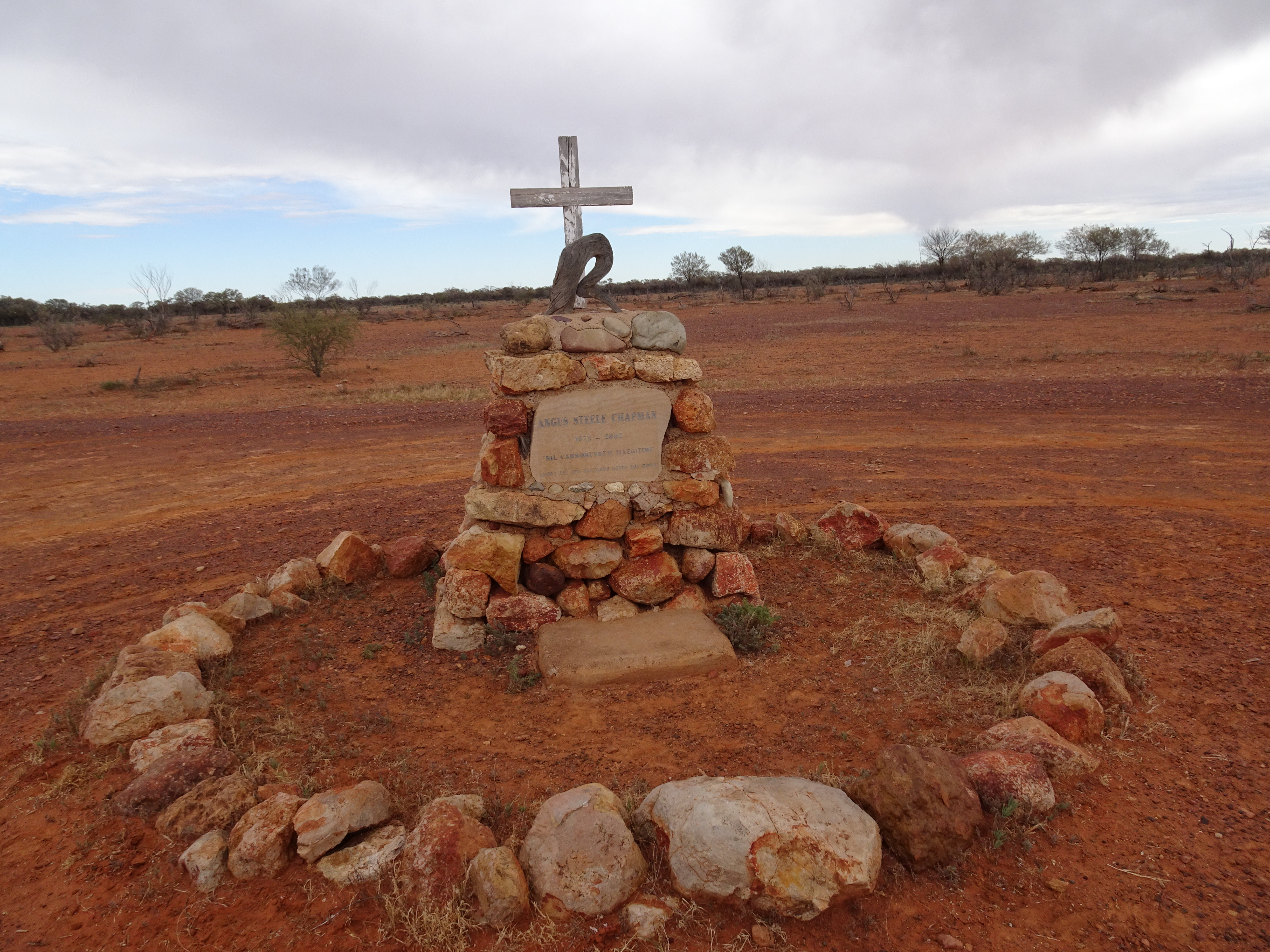
There were regular signs warning of 53 metres long road trains and advising traffic to pull off the road if they were spotted approaching! I stopped in Eromanga, described as the town in Australia located the farthest from any ocean, for coffee, solids and fuel and then continued to Quilpie. On the way I stopped to look at an unusual roadside memorial. Later enquiries revealed that it appears that the young man concerned died as the result of a motorcycle accident.

I passed through an area which appeared to have been scarred by bushfires but I discovered that the stumps were remnants of acacia trees which had been destroyed by a swarm of locusts several decades earlier.

In Quilpie I booked into the Heritage Inn, a smart place recently refurbished in a shabby chic style and although my room was well decorated and fitted out there was no chair in which to relax! The barman was a young backpacker from Northern Ireland who had been working on fruit farms and as the fruit season had ended he had secured this job for several months rather than returning to Ireland where the Covid-19 situation was worse. He and his girlfriend had volunteered for several months with the Rural Fire Service at the height of the bushfire crisis and as a result had earned the right to remain in Australia for a further 12 months. I enjoyed a really scrumptious lamb shank for dinner. I had noticed that the hotel website was under construction and I looked at Tripadvisor which stated that breakfast was included, but when I enquired I was told by the manager that it wasn’t and that the Tripadvisor information had been posted by the previous owner. I suggested that an update was in order.
Distance: 380 kilometres.
Thursday 23rd July
I started the day with an egg and bacon roll and coffee from the local bakery and sat in glorious early morning sunshine to consume them.

I enjoyed a nice day’s ride, albeit unremarkable, and I had my first sighting in several days of a red kangaroo, other than roadkill, as it bounded parallel to the road for some distance. I stopped for lunch in Charleville, a nice town, and decided to find a place to stay in Mitchell, a further 180kms of pleasant road. I found a good, reasonably priced motel with a most accommodating owner who even went as far as lending DVDs and a player to guests. As I was unloading the bike I got into conversation with a bloke in the next room. He very kindly gave me a beer and he showed me a dent and broken headlight on the front left side of his ute. Apparently, that morning, he had been driving relatively slowly approaching a town when a kangaroo jumped into the road in front of him and he hit it, hence the damage. He was quite sanguine about it and coming from further north in Queensland he considered such incidents the norm. Maybe so, but quite thought provoking when riding a bike! I walked to the town hotel/pub where I enjoyed a couple of beers and chatted to the landlady and her husband, a long distance lorry driver. She told me that she had been visited by two inspectors earlier in the day at about breakfast time and they examined her COVID-19 precautions, both documentary and physical, which took most of the day. She complained that she had finally managed to eat her breakfast at 3 in the afternoon.
Distance: 386 kilometres.
Friday 24th July
I started the day with a coffee at the bakery, as had become my norm, and I decided to go to Injune before Roma. The reason was that over a decade earlier Daphne and I had been driving through Injune on our way back to the Gold Coast having camped at Carnarvon Gorge when I spotted the name of the local park which contained the name ‘Laycock’.

I went to the tourist information office (even the smallest of towns in Australia seem to have one) where I discovered that there was a reasonably large community of Laycocks in the area. I was referred to the adjacent library where the librarian was named Laycock, albeit by marriage I discovered. She said that her father-in-law was very knowledgeable about the name locally and that she was sure he would be delighted to speak to me. I decided that we didn’t have the time to stay there any longer so we continued on our journey. So, now I did have the time, hence the decision to go there.
I rode a lovely quiet road, flanked by very arid vegetation, and crossed The Great Dividing Range before dropping down to Injune.


I again went to the information office which was manned by an elderly lady who was very interested in my story and before I knew it she had a Laycock on the phone. This lady, Shirley, worked in the motel along the road and I was invited to go and speak to her. We met and in conversation she said that her sister was the family historian and that she was sure that she would be keen to speak to me. She said she would telephone her sister, Robyn, and make arrangements for her to contact me. I assumed, wrongly it turned out, that she was also in Injune and so I decided to stay in the motel overnight rather than continue to Roma.

After booking in I went across the road to a tyre workshop where I borrowed an electric drill to make holes in the bottom of my damaged pannier to allow water to drain out as it was no longer waterproof and rain was forecast. I had already bought heavy duty plastic bags into which I had put my spares and tools etc. When I explained to the guy in the workshop the reason for it he said that he hoped it did rain as they were in the middle of a drought!

I wandered around the town in the afternoon and called into the library where Sue Laycock, the librarian I had spoken to all those years ago, was still in post. We had a lengthy chat in which I discovered that her father-in-law had died the previous year. I popped into the (only) local pub to investigate the possibility of dinner that evening and was advised to book a table as Friday night tended to get busy.
When I returned to the motel I received a phone call from Robyn. She lived in Townsville, a place some distance away on the coast. We had a long conversation about Laycocks generally and she emailed me several documents and photos which turned out to be very interesting. She explained that she had travelled extensively researching the name and she mentioned a Dr John Laycock who lived not far from me in England and who was compiling a detailed history of Laycocks around the world. Just before 1800 Shirley knocked on my door and she came in and showed me a heap of documents and photos of Laycocks over the years around Injune and Roma. She stayed for an hour and left me with a folder of information for me to peruse. I did read a booklet detailing their family history beginning with the first who had arrived from Yorkshire in the early 19th century.
I enjoyed a good steak for dinner, it is cattle country after all. The main bar was very busy with, it appeared, little regard being paid to social distancing.
Distance: 153 kilometres.
Saturday 25th July
I departed Injune in sunshine and visited the site of the Injune coal mine on the edge of town which was worked to supply the now defunct railway.

I rode to Roma where I stopped for refreshments and to refuel. I almost lost my temper at the petrol station at the way the officious middle aged female jobsworth behind the counter instructed me to remove my helmet, normally not an unreasonable request, and I quote “Federal and State Law says that masks and balaclavas should be removed before entering shops.” I wondered how the advice to wear masks in shops because of Covid sat with her. Reassuring to know that even when having a great time I remain a grumpy old man!
Today was emu day: I saw a large number, both singly and in groups (flocks?) in the land flanking the road.


I saw evidence of the famous Cobb & Co coach service.

The sky was beginning to darken and it looked as if it might rain so I decided to stop and phone to book some overnight accommodation. I plumped for Dirrabandi and spoke to the motel and was told that they were full. I connected to booking.com to seek alternatives only to find the motel at Dirrabandi was listed as having two rooms available, so I booked one. On arrival I found the room ready for me. A mystery.
As I was unloading the bike I saw a chap doing quite extreme circuit training in the courtyard. I discovered later he was one of half a dozen soldiers staying at the motel. I ate in the local pub and enjoyed a very nice grilled barramundi. Later that night the heavens opened and it rained cats and dogs.
Distance: 372 kilometres.
Sunday 26th July
It was dull and overcast as I left the motel and I stopped after just a new hundred metres to don wet weather trousers as it had started to drizzle. After about 60kms I reached the hamlet of Hebel where I refuelled at an unmanned pump and had coffee and a pie in a quaint roadhouse. The owner said the the only pie he had left was beef, bacon and cheese although he had forgotten to put in the cheese! On the edge of the hamlet was a police caravan manned by two police officers and a couple of soldiers, the Queensland checkpoint inspecting authorisations to cross the border. I crossed back into New South Wales and made my way to Lightning Ridge, the home of the black opal. The town appeared to be one long street of motels, caravan parks, cafes and opal shops. It appears that people come because of the opal mine tours and ............
I was planning to spend the night at Brewarrina, a place I had passed through heading east on my last trip. I phoned the only motel and booked a room - the key would be left in a key safe outside the room and the owner would telephone me later in the evening to arrange payment. I arrived just after 1600 having ridden a familiar road for a couple of hours. I saw an echidna and soon afterwards an enormous (4 feet long) monitor lizard scuttling across the road. I stopped to take some photographs of some interesting flooded woodland.


On arrival I met a couple from Victoria who were unloading their vehicles. The wife was a doctor who was in Brewarrina for 13 weeks and in her words “working as a GP, hospital doctor, community doctor serving a large local area, and everything else in between”. Her husband spent his time supporting her and undertaking all the domestic chores etc. A little later three motorcycles arrived. They were ridden by a couple who had just started a year long tour of Australia. They had booked a year off work to tour the USA and Canada but had to cancel because of covid and so decided to investigate their homeland instead. The woman was riding an XT250 and her husband a GS650 Dakar, both fully laden with camping gear etc. The woman had learned to ride after she had reached the age of 50 as she was bored with being the pillion. The other guy, their mate from home, was riding a Tenere 700 and was accompanying them only as far as Brisbane where he was to visit his daughter.
I went to the local RSL for dinner and a beer and was impressed when at 1900 all activity ceased, the lights were dimmed and a recording of the last post was played together with the words of ‘Ode of Remembrance’. Apparently this is done in most RSL clubs in Australia. Again, the restaurant was Chinese and I had a meal which was both plentiful and of reasonable quality. As I had noticed in all of the clubs I had visited in rural Australia the pokie, i.e. the gaming machines room, were heavily patronised by the indigenous community.
The motel was very quirky with disparate domestic furniture and a supplied continental breakfast consisting of cereal, toast and hot drinks.
Distance: 349 kilometres.
Monday 27th July
I left Brewarrina with the intention of spending the night in Tottenham. In the event, although a minor road, the surface was smooth and I made good time. On the way I disturbed a red fox beside the road, the first I had seen, and I was struck at how much prettier was its face compared to our home examples. Soon afterwards I passed a red feral goat!! On arrival in Nyngan at lunchtime I decided to travel on to Condobolin to spend the night. I had plotted a route on sealed minor roads but after about 40 kilometres I reached a crossroads leading to three unsealed roads. I consulted my map and it contradicted what I could see and my TomTom was programmed to avoid unsealed roads. Condobolin was signposted and I thought that perhaps this was merely a short unsealed section. What a nightmare! Because of the recent rain there were numerous large puddles and riverlets crossing the road, water filled ruts and very slippery mud. After some time I became confused by the direction of travel indicated by the GPS and when I reached a junction with a small sign indicating Tullamore I decided to head there. Fortunately, after only 10kms or so the road became sealed. I was very relieved to be back on bitumen which lead me to Tullamore and on to Condobolin where I found a room in a motel in the middle of town across the road from a good pub.
Having experienced a wide range of unsealed road surfaces I admit to being totally uncomfortable on sand and mud. I have come to the conclusion that choice of tyre should be dictated by the worst surface anticipated and not by the proportion of road/off road riding. Perhaps my sand/dust/mud experiences would have been more enjoyable had I had more aggressive knobblies.
It started to rain during the evening and I moved the bike to underneath the overhang outside my room. I am glad I did as it tipped it down most of the night.
Distance: 424 kilometres.
Tuesday 28th July
As it is only about 270kms from Condobolin to Wagga Wagga I decided to visit the Parkes Radio Telescope, famous for relaying the best pictures of the moon landing in 1969 and the subject of the feature film “The Dish”, a distance of 125kms east of Condobolin. It was a glorious sunny day and I relied on my TomTom to direct me there. I couldn’t believe it - more unsealed roads, albeit only a few kilometres.


It was a fascinating visit and I was fortunate to be there during a maintenance period so I was able to witness the dish being moved to various angles. I sat through a fascinating 30 minutes of 3D films depicting astronomy, the moon and Mars exploration. Whilst relaxing over a coffee I suddenly realised that I still had about 300kms to go before reaching Wagga so I set off riding almost due south with the temperature falling as I travelled. I reached Wagga before dark, again delighted with the performance of the Himalayan.
Distance: 430 kilometres.
This trip was a couple of days shorter than anticipated. I had planned to stay more than one night in several locations but in the event there was nowhere other than Wilcannia that warranted an extended stay.
I have received various opinions and advice about riding on sand and bulldust. One school of thought is that it is best to accelerate out of it whilst another is to maintain a constant speed, but in both to lean back to lighten the weight on the front wheel. I will bear both in mind if and when I encounter it again.
Despite the fall, the trip was most enjoyable and I was fascinated by the disparate terrain I traversed, particularly the desert areas.

Total distance travelled: 3,857 kilometres.